
Live from the National Weather Service

    California Storm Alerts

    Active National Weather Service hail, wind, thunderstorm, tornado, tropical and winter storm alerts covering California, with the counties each one names and the office that issued it — plus what the state’s severe-weather season looks like and how each of these events actually damages a roof.

    Below that, in its own lane, the smoke and fire family: fire weather, dense smoke, air quality, blowing dust and volcanic ashfall.

    2 active alerts · read from the National Weather Service at Aug 26, 1:54 AM EDT · refreshed every 10 minutes

    This page is informational and is not a safety resource. It exists to show roofing professionals where storm damage has been reported, and it is refreshed on a ten-minute cycle, so it can lag the Weather Service.

    During an active weather event, the authority is weather.gov and your local emergency management agency. Follow them, not this page.

    Active storm alerts in California

    Reproduced exactly as the National Weather Service issued them. Alerts frequently cross state lines, so a county list may name counties in a neighbouring state. Smoke and fire alerts are reported separately, in their own lane below.

    Wind Advisory

    ModerateUrgencyExpectedCertaintyLikely

    Issued by NWS Los Angeles/Oxnard CA

    In effect from Aug 25, 8:37 PM local · until Aug 26, 6:00 AM local

    Counties named in this alert

    • Santa Ynez Mountains Western Range
    Read the full National Weather Service text

    NWS headline

    Wind Advisory issued August 25 at 8:37PM PDT until August 26 at 6:00AM PDT by NWS Los Angeles/Oxnard CA

    NWS description

    * WHAT...For the Wind Advisory, north winds 20 to 30 mph with gusts up to 45 mph. For the Extreme Heat Warning, dangerously hot conditions with high temperatures of 100 to 110 common. * WHERE...Santa Ynez Mountains Western Range. * WHEN...For the Wind Advisory, until 6 AM PDT Wednesday. For the Extreme Heat Warning, until 8 PM PDT Friday. * IMPACTS...There is a high risk for dangerous heat illness, especially for sensitive groups like the very young, the very old, those without air conditioning, and those active outdoors. Gusty winds will blow around unsecured objects. Tree limbs could be blown down and a few power outages may result.

    NWS instructions

    Drink plenty of fluids, stay in an air-conditioned room, stay out of the sun, and check up on relatives and neighbors. Do not leave young children and pets in unattended vehicles. Limit strenuous activities to early morning or evening hours. Take action when you see symptoms of heat exhaustion. Winds this strong can make driving difficult, especially for high profile vehicles. Use extra caution. Secure outdoor objects.

    View this alert on weather.gov

    Wind Advisory

    ModerateUrgencyExpectedCertaintyLikely

    Issued by NWS Los Angeles/Oxnard CA

    In effect from Aug 25, 8:37 PM local · until Aug 26, 6:00 AM local

    Counties named in this alert

    • Santa Barbara County Southwestern Coast
    Read the full National Weather Service text

    NWS headline

    Wind Advisory issued August 25 at 8:37PM PDT until August 26 at 6:00AM PDT by NWS Los Angeles/Oxnard CA

    NWS description

    * WHAT...For the Wind Advisory, North winds 20 to 30 mph with gusts up to 45 mph. For the Extreme Heat Warning, dangerously hot conditions with high temperatures of 92 to 102 common. * WHERE...Santa Barbara County Southwestern Coast. * WHEN...For the Wind Advisory, until 6 AM PDT Wednesday. For the Extreme Heat Warning, until 8 PM PDT Friday. * IMPACTS...There is a high risk for dangerous heat illness, especially for sensitive groups like the very young, the very old, those without air conditioning, and those active outdoors. Gusty winds will blow around unsecured objects. Tree limbs could be blown down and a few power outages may result.

    NWS instructions

    Drink plenty of fluids, stay in an air-conditioned room, stay out of the sun, and check up on relatives and neighbors. Do not leave young children and pets in unattended vehicles. Limit strenuous activities to early morning or evening hours. Take action when you see symptoms of heat exhaustion. Winds this strong can make driving difficult, especially for high profile vehicles. Use extra caution. Secure outdoor objects.

    View this alert on weather.gov

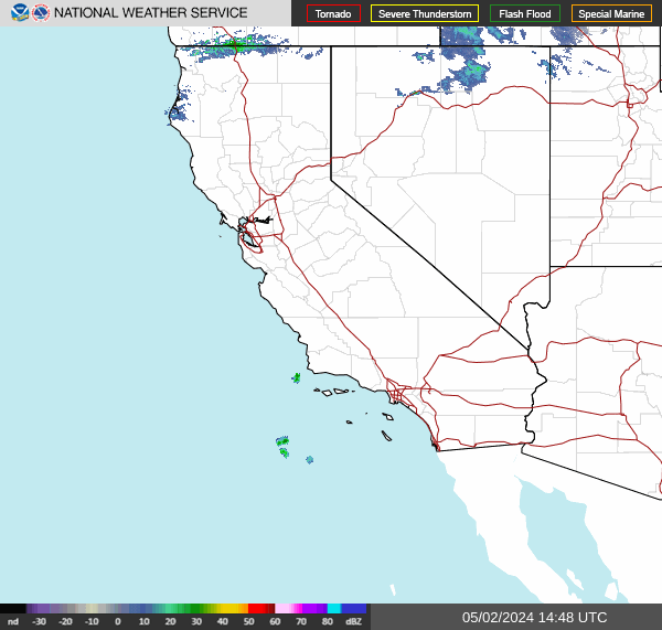
    Radar over California

    Straight from radar.weather.gov and regenerated by NOAA roughly every two minutes.

    NWS radar — the Pacific Southwest

    National Weather Service radar for the Pacific Southwest, covering California and Nevada.

    Where precipitation is falling over California right now. The National Weather Service publishes these mosaics by region rather than by state, so the frame runs past the state line and neighbouring states are visible in it. Radar shows precipitation, not damage — a return over a county is not evidence that any particular building was hit.

    Radar imagery: the National Weather Service. Served directly from radar.weather.gov, a free US Government service, and regenerated by NOAA roughly every two minutes — your browser picks up new frames on its own. This site does not process, re-colour or re-time the imagery; it is the Weather Service’s own mosaic, unmodified. weather.gov

    This radar is informational and is not a safety resource. During an active weather event, the authority is weather.gov and your local emergency management agency. Follow them, not this page.

    Smoke & fire lane

    Smoke & fire alerts in California

    The National Weather Service issues a separate family of alerts for fire weather, dense smoke, air quality, blowing dust and volcanic ashfall. This lane reports that family for California, kept apart from the storm alerts above because the two answer different questions.

    Wildfire smoke is what drives smoke-damage losses, and it reaches a building through the same vents that keep an attic dry — which is why it belongs on a roofing page at all. Alerts describing particulate already in the air are listed ahead of fire-weather forecasts; that ordering is this lane’s own and is not a Weather Service ranking.

    8 active smoke or fire alerts · read from the National Weather Service at Aug 26, 1:54 AM EDT · refreshed every 10 minutes

    Air Quality Alert

    Air qualityUnknownUrgencyUnknownCertaintyUnknown

    Issued by NWS San Diego CA

    In effect from Aug 24, 1:34 PM local · until Aug 28, 8:00 PM local

    Counties named in this alert

    • San Bernardino and Riverside County Valleys-The Inland Empire
    • San Bernardino County Mountains
    • Coachella Valley
    • San Gorgonio Pass Near Banning
    • Orange County Inland
    Read the full National Weather Service text

    NWS headline

    Air Quality Alert issued August 24 at 1:34PM PDT by NWS San Diego CA

    NWS description

    * WHAT...The South Coast AQMD has issued an air quality alert due to harmful levels of ozone pollution. Visit https://www.aqmd.gov/alertinfo to check current and forecasted air quality levels. * WHERE...in the the South Coast Air Basin and Coachella Valley. Levels of ozone pollution can vary by time and location depending on emissions and air pollution transport. * WHEN...from 1 PM Monday to 8 PM Friday. The highest ozone levels typically occur in the afternoon and early-evening hours. * IMPACTS... Ozone air pollution can cause serious health problems, including trouble breathing, asthma attacks, and lung damage. Everyone can be affected, but sensitive groups such as people with lung disease, older adults, people who are pregnant, children, and those who spend a lot of time outdoors are at greater risk.

    NWS instructions

    To protect your health, check air quality levels and act as needed: * When Air Quality Index (AQI) levels are "Unhealthy for Sensitive Groups" (orange), sensitive groups as specified above should limit extended or intense outdoor activity. * When AQI is "Unhealthy" (red), everyone may experience health impacts. Sensitive groups should avoid extended time outdoors. * When AQI is "Very Unhealthy" (purple), sensitive groups should avoid all outdoor physical activity. Everyone else should avoid extended or intense outdoor activity. * When AQI is "Hazardous" (maroon), everyone should avoid all outdoor physical activity. * ADDITIONAL DETAILS... To help keep indoor air clean when air quality is poor: * Keep windows and doors closed * Run your air conditioner and/or an air purifier * Do not use whole house fans or swamp coolers that bring in outside air if you have other methods to stay cool * Avoid other sources of pollution such as fireplaces, candles, incense, and grilling To help minimize outdoor ozone air pollution levels: * Limit the use of gasoline powered lawn and garden equipment until evening hours * Try to delay trips to the gas station and the use of household chemicals until the evening For the latest air quality forecasts and information, visit the website at aqmd.gov.

    View this alert on weather.gov

    Air Quality Alert

    Air qualityUnknownUrgencyUnknownCertaintyUnknown

    Issued by NWS Los Angeles/Oxnard CA

    In effect from Aug 25, 6:39 AM local · until Aug 28, 8:00 PM local

    Counties named in this alert

    • Eastern San Fernando Valley
    • Eastern San Gabriel Mountains
    • Interstate 5 Corridor
    • Los Angeles County Inland Coast including Downtown Los Angeles
    • Los Angeles County San Gabriel Valley
    • Santa Clarita Valley
    • Santa Susana Mountains
    • Western San Fernando Valley
    • Western San Gabriel Mountains and Highway 14 Corridor
    Read the full National Weather Service text

    NWS headline

    Air Quality Alert issued August 25 at 6:39AM PDT by NWS Los Angeles/Oxnard CA

    NWS description

    * WHAT...The South Coast AQMD has issued an air quality alert due to harmful levels of ozone pollution. Visit https://www.aqmd.gov/alertinfo to check current and forecasted air quality levels. * WHERE...in the the South Coast Air Basin and Coachella Valley. Levels of ozone pollution can vary by time and location depending on emissions and air pollution transport. * WHEN...from 1 PM Monday to 8 PM Friday. The highest ozone levels typically occur in the afternoon and early-evening hours. * IMPACTS... Ozone air pollution can cause serious health problems, including trouble breathing, asthma attacks, and lung damage. Everyone can be affected, but sensitive groups such as people with lung disease, older adults, people who are pregnant, children, and those who spend a lot of time outdoors are at greater risk.

    NWS instructions

    To protect your health, check air quality levels and act as needed: * When Air Quality Index (AQI) levels are "Unhealthy for Sensitive Groups" (orange), sensitive groups as specified above should limit extended or intense outdoor activity. * When AQI is "Unhealthy" (red), everyone may experience health impacts. Sensitive groups should avoid extended time outdoors. * When AQI is "Very Unhealthy" (purple), sensitive groups should avoid all outdoor physical activity. Everyone else should avoid extended or intense outdoor activity. * When AQI is "Hazardous" (maroon), everyone should avoid all outdoor physical activity. * ADDITIONAL DETAILS... To help keep indoor air clean when air quality is poor: * Keep windows and doors closed * Run your air conditioner and/or an air purifier * Do not use whole house fans or swamp coolers that bring in outside air if you have other methods to stay cool * Avoid other sources of pollution such as fireplaces, candles, incense, and grilling To help minimize outdoor ozone air pollution levels: * Limit the use of gasoline powered lawn and garden equipment until evening hours * Try to delay trips to the gas station and the use of household chemicals until the evening

    View this alert on weather.gov

    Air Quality Alert

    Air qualityUnknownUrgencyUnknownCertaintyUnknown

    Issued by NWS Los Angeles/Oxnard CA

    In effect from Aug 25, 7:55 AM local · until Aug 28, 8:00 PM local

    Counties named in this alert

    • Eastern San Fernando Valley
    • Eastern San Gabriel Mountains
    • Interstate 5 Corridor
    • Los Angeles County Inland Coast including Downtown Los Angeles
    • Los Angeles County San Gabriel Valley
    • Santa Clarita Valley
    • Santa Susana Mountains
    • Western San Fernando Valley
    • Western San Gabriel Mountains and Highway 14 Corridor
    Read the full National Weather Service text

    NWS headline

    Air Quality Alert issued August 25 at 7:55AM PDT by NWS Los Angeles/Oxnard CA

    NWS description

    * WHAT...The South Coast AQMD has issued an air quality alert due to harmful levels of ozone pollution. Visit https://www.aqmd.gov/alertinfo to check current and forecasted air quality levels. * WHERE...in the the South Coast Air Basin and Coachella Valley. Levels of ozone pollution can vary by time and location depending on emissions and air pollution transport. * WHEN...from 1 PM Monday to 8 PM Friday. The highest ozone levels typically occur in the afternoon and early-evening hours. * IMPACTS... Ozone air pollution can cause serious health problems, including trouble breathing, asthma attacks, and lung damage. Everyone can be affected, but sensitive groups such as people with lung disease, older adults, people who are pregnant, children, and those who spend a lot of time outdoors are at greater risk.

    NWS instructions

    To protect your health, check air quality levels and act as needed: * When Air Quality Index (AQI) levels are "Unhealthy for Sensitive Groups" (orange), sensitive groups as specified above should limit extended or intense outdoor activity. * When AQI is "Unhealthy" (red), everyone may experience health impacts. Sensitive groups should avoid extended time outdoors. * When AQI is "Very Unhealthy" (purple), sensitive groups should avoid all outdoor physical activity. Everyone else should avoid extended or intense outdoor activity. * When AQI is "Hazardous" (maroon), everyone should avoid all outdoor physical activity. * ADDITIONAL DETAILS... To help keep indoor air clean when air quality is poor: * Keep windows and doors closed * Run your air conditioner and/or an air purifier * Do not use whole house fans or swamp coolers that bring in outside air if you have other methods to stay cool * Avoid other sources of pollution such as fireplaces, candles, incense, and grilling To help minimize outdoor ozone air pollution levels: * Limit the use of gasoline powered lawn and garden equipment until evening hours * Try to delay trips to the gas station and the use of household chemicals until the evening

    View this alert on weather.gov

    Air Quality Alert

    Air qualityUnknownUrgencyUnknownCertaintyUnknown

    Issued by NWS Hanford CA

    In effect from Aug 25, 11:08 AM local · until Aug 27, 11:00 AM local

    Counties named in this alert

    • Merced, CA
    Read the full National Weather Service text

    NWS headline

    Air Quality Alert issued August 25 at 11:08AM PDT by NWS Hanford CA

    NWS description

    Exposure to particle pollution can cause serious health problems; aggravate lung disease, cause asthma attacks and acute bronchitis and increase risk of respiratory infections. In people with heart disease, short-term exposure to particle pollution has been linked to heart attacks and arrhythmias according to the US Environmental Protection Agency. Children and elderly people are also more susceptible to consequences of high particulate levels. Stay indoors if possible. Avoid prolonged or strenuous outdoor physical activities to reduce the affect of unhealthy air. For current air quality go to fire.airnow.gov

    View this alert on weather.gov

    Red Flag Warning

    Fire weatherSevereUrgencyExpectedCertaintyLikely

    Issued by NWS Los Angeles/Oxnard CA

    In effect from Aug 25, 2:57 PM local · until Aug 28, 3:00 PM local

    Counties named in this alert

    • Cuyama Valley
    • San Luis Obispo County Mountains
    • Santa Barbara County Interior Mountains
    • Southern Ventura County Mountains
    • Northern Ventura County Mountains
    • Interstate 5 Corridor
    • Western San Gabriel Mountains and Highway 14 Corridor
    Read the full National Weather Service text

    NWS headline

    Red Flag Warning issued August 25 at 2:57PM PDT until August 28 at 3:00PM PDT by NWS Los Angeles/Oxnard CA

    NWS description

    ...RED FLAG WARNING IN EFFECT THROUGH 3 PM FRIDAY FOR MANY INTERIOR PORTIONS OF SOUTHWEST CALIFORNIA DUE TO EXTREME HEAT AND INSTABILITY ALONG WITH LOCALLY GUSTY WINDS AND LOW HUMIDITIES... .A very hot and unstable air mass combined with locally gusty winds and low humidities will bring a significant risk of large plume dominated fires with rapid spread and extreme fire behavior. * TEMPERATURES...Highs 100 to 110 across the lower mountains, adjacent foothills and the Cuyama Valley, and 85 to 95 across higher mountains. Lows in the mid 70s to mid 80s common in the mountains and foothills. * INSTABILITY...Very deep mixing heights of 12,000 to 20,000 feet today through Thursday, slightly lower on Friday. * WINDS...Local northwest to north winds 15 to 25 mph with gusts up to 35 mph at times, strongest across the I-5 and Highway 33 corridors. A slightly stronger northerly wind push is possible late Thursday night into Friday morning, with gusts up to 40 mph possible across the I-5 corridor. * RELATIVE HUMIDITY...Minimum humidities 10 to 20 percent each day, with isolated values as low as 7 percent Wednesday through Friday. Poor recoveries overnight hours in the mountains and foothills with humidities in the 15 to 30 percent range. * IMPACTS...There is a significant risk of large plume dominated fires with rapid fire spread and extreme fire behavior. There is a history of large plume dominated fires this time of year with similar weather and fuel conditions, including the Bridge, Bobcat, and Station fires.

    NWS instructions

    A Red Flag Warning means that critical fire weather conditions will occur shortly. Use extreme caution with anything that can spark a wildfire. Residents near wildland interfaces should be prepared to evacuate if a wildfire breaks out. See readyforwildfire.org and wildfirerisk.org for information.

    View this alert on weather.gov

    Red Flag Warning

    Fire weatherSevereUrgencyExpectedCertaintyLikely

    Issued by NWS Los Angeles/Oxnard CA

    In effect from Aug 25, 2:57 PM local · until Aug 28, 3:00 PM local

    Counties named in this alert

    • Santa Susana Mountains
    • Eastern San Gabriel Mountains
    Read the full National Weather Service text

    NWS headline

    Red Flag Warning issued August 25 at 2:57PM PDT until August 28 at 3:00PM PDT by NWS Los Angeles/Oxnard CA

    NWS description

    ...RED FLAG WARNING IN EFFECT THROUGH 3 PM FRIDAY FOR MANY INTERIOR PORTIONS OF SOUTHWEST CALIFORNIA DUE TO EXTREME HEAT AND INSTABILITY ALONG WITH LOCALLY GUSTY WINDS AND LOW HUMIDITIES... .A very hot and unstable air mass combined with locally gusty winds and low humidities will bring a significant risk of large plume dominated fires with rapid spread and extreme fire behavior. * TEMPERATURES...Highs 96 to 106 across the lower elevations. Highs 85 to 95 common across the higher mountains. Lows in the mid 70s to mid 80s common in the mountains and foothills. * INSTABILITY...Very deep mixing heights of 12,000 to 18,000 feet today through Thursday, slightly lower on Friday. * WINDS...Southwest 10 to 20 mph with gusts 20 to 30 mph each afternoon into early evening. * RELATIVE HUMIDITY...Minimum humidities 10 to 20 percent each day, Poor recoveries overnight hours in the mountains and foothills with humidities in the 15 to 30 percent range. * IMPACTS...There is a significant risk of large plume dominated fires with rapid fire spread and extreme fire behavior. There is a history of large plume dominated fires this time of year with similar weather and fuel conditions, including the Bridge, Bobcat, and Station fires.

    NWS instructions

    A Red Flag Warning means that critical fire weather conditions will occur shortly. Use extreme caution with anything that can spark a wildfire. Residents near wildland interfaces should be prepared to evacuate if a wildfire breaks out. See readyforwildfire.org and wildfirerisk.org for information.

    View this alert on weather.gov

    Red Flag Warning

    Fire weatherSevereUrgencyExpectedCertaintyLikely

    Issued by NWS Medford OR

    In effect from Aug 26, 11:00 AM local · until Aug 26, 8:00 PM local

    Counties named in this alert

    • Modoc County Except for the Surprise Valley
    • Klamath Basin and the Fremont-Winema National Forest
    • South Central Oregon Desert including the BLM Land in Eastern Lake and Western Harney Counties
    Read the full National Weather Service text

    NWS headline

    Red Flag Warning issued August 25 at 5:32PM PDT until August 26 at 8:00PM PDT by NWS Medford OR

    NWS description

    ...FIRE WEATHER WATCH REMAINS IN EFFECT FROM THURSDAY MORNING THROUGH THURSDAY EVENING FOR STRONG GUSTY WIND AND LOW RH FOR FIRE WEATHER ZONES 285, 624, AND 625... * IMPACTS...Any fires that develop will likely spread rapidly. * AFFECTED AREA...In California...Fire weather zone 285. In Oregon...Fire weather zone 624, mainly from around the Wright's Spring Fire and Bonanza eastward...and all of fire weather zone 625. * WIND...South to southwest at 15 to 25 mph with gusts of 30 to 40 mph both days. * HUMIDITY...Daytime humidities down around 9 to 15 percent both days. * DETAILED URL...View the hazard area in detail at https://weather.gov/wrh/hazards?wfo=mfr

    NWS instructions

    Follow all fire restrictions. You can find your county's emergency sign up form as well as links to fire restrictions at weather.gov/medford/wildfire. One less spark, one less wildfire. Be sure you're signed up for your county's emergency alert system. Familiarize yourself with your emergency plan and make sure you listen to emergency services. Visit ready.gov/plan for more information. A Red Flag Warning is issued when we identify weather conditions that promote rapid spread of fire which may become life- threatening. This does not mean there is a fire. These conditions are either occurring now or will begin soon. It is important to have multiple ways to receive information from authorities. If you have not packet your go kit yet, now is the time to do so. This includes items like important documents and essentials you cannot live without. Fill your vehicle's fuel tank. Visit ready.gov/kit for more information.

    View this alert on weather.gov

    Fire Weather Watch

    Fire weatherSevereUrgencyFutureCertaintyPossible

    Issued by NWS Medford OR

    In effect from Aug 27, 11:00 AM local · until Aug 27, 8:00 PM local

    Counties named in this alert

    • Modoc County Except for the Surprise Valley
    • Klamath Basin and the Fremont-Winema National Forest
    • South Central Oregon Desert including the BLM Land in Eastern Lake and Western Harney Counties
    Read the full National Weather Service text

    NWS headline

    Fire Weather Watch issued August 25 at 5:32PM PDT until August 27 at 8:00PM PDT by NWS Medford OR

    NWS description

    ...FIRE WEATHER WATCH REMAINS IN EFFECT FROM THURSDAY MORNING THROUGH THURSDAY EVENING FOR STRONG GUSTY WIND AND LOW RH FOR FIRE WEATHER ZONES 285, 624, AND 625... * IMPACTS...Any fires that develop will likely spread rapidly. * AFFECTED AREA...In California...Fire weather zone 285. In Oregon...Fire weather zone 624, mainly from around the Wright's Spring Fire and Bonanza eastward...and all of fire weather zone 625. * WIND...South to southwest at 15 to 25 mph with gusts of 30 to 40 mph both days. * HUMIDITY...Daytime humidities down around 9 to 15 percent both days. * DETAILED URL...View the hazard area in detail at https://weather.gov/wrh/hazards?wfo=mfr

    NWS instructions

    Follow all fire restrictions. You can find your county's emergency sign up form as well as links to fire restrictions at weather.gov/medford/wildfire. One less spark, one less wildfire. Be sure you're signed up for your county's emergency alert system. Familiarize yourself with your emergency plan and make sure you listen to emergency services. Visit ready.gov/plan for more information. A Red Flag Warning is issued when we identify weather conditions that promote rapid spread of fire which may become life- threatening. This does not mean there is a fire. These conditions are either occurring now or will begin soon. It is important to have multiple ways to receive information from authorities. If you have not packet your go kit yet, now is the time to do so. This includes items like important documents and essentials you cannot live without. Fill your vehicle's fuel tank. Visit ready.gov/kit for more information.

    View this alert on weather.gov

    The 12 alert types this lane reports

    Every one is a National Weather Service product and is listed under the name the Weather Service gives it. Grouping them into families is ours; the names are not.

    Fire weather
    Fire WarningExtreme Fire DangerRed Flag WarningFire Weather Watch
    Dense smoke
    Dense Smoke Advisory
    Air quality
    Air Quality Alert
    Blowing dust
    Blowing Dust WarningDust Storm WarningBlowing Dust AdvisoryDust Advisory
    Volcanic ashfall
    Ashfall WarningAshfall Advisory

    The Weather Service defines each of these products and this site does not attempt to. What any one of them means, and the criteria an office issues it under, are at weather.gov.

    This lane is informational and is not a safety resource. It reports which National Weather Service smoke and fire alerts are active and where, on a ten-minute refresh cycle, so it can lag the Weather Service.

    During an active weather event, the authority is weather.gov and your local emergency management agency. Follow them, not this page.

    Smoke exposure and air quality are health matters, and this page does not address them. It does not tell you whether it is safe to be outdoors or to work, what an air quality index number means for you or for anyone in your household, or what respiratory protection to use. Those questions belong with a clinician and with the agency that issued the alert. The federal air-quality authority is airnow.gov.

    What smoke does to a roof assembly

    An active alert is a record of conditions, not a finding about any building. These are the standing references on the building-assembly side of a smoke or fire loss.

    Severe weather season in California

    Peak season

    November–March, plus autumn offshore wind events

    California’s roof-damaging weather is mostly a winter pattern. Pacific storm systems and atmospheric rivers bring sustained rain and wind, and the long duration is what tends to find a tired flashing or an unsealed penetration. Autumn adds the offshore wind events — Santa Ana in the south, Diablo in the north — which can produce damaging gusts with no rain at all. Hail and tornadoes are uncommon across most of the state.

    Seasons describe a pattern, not a schedule. The National Weather Service issues these products year-round, and the live list above is the only authority on what is actually running in California right now.

    What NOAA has recorded in California

    The archived record, not the live feed. Severe weather logged by the National Centers for Environmental Information over the covered years, split into the events NOAA keys to a county and the events it keys to a forecast zone.

    Between 2016 and 2026, NOAA recorded 942 county-level severe-weather events across California: 555 thunderstorm wind events, 321 hail reports, 64 tornadoes, 1 high wind event and 1 strong wind event. Of the 321 hail reports carrying a measured size, 85 were 1.00 in across or larger.

    A further 7,736 events over the same period were recorded against National Weather Service forecast zones rather than counties — 4,029 high wind events, 1,790 heavy snow events, 1,372 strong wind events, 506 winter storms and 21 blizzards. A forecast zone is not a county: it can span several or subdivide one, so these are reported here at state level and appear in no county total on this site.

    County-keyed events

    942

    2016–2026

    Zone-keyed events

    7,736

    statewide, not county-attributable

    Hail 1.00 in or larger

    85

    of 321 sized hail reports

    Tornadoes

    64

    in the county record

    Counties with the heaviest record

    Ranked by the number of county-keyed events NOAA recorded, 20162026. 56 of California’s counties carry a record in this dataset.

    • San Bernardino County82largest hail 1.75 in (Golf Ball) · peak gust 75 kt (about 86 mph)
    • San Diego County67largest hail 1.00 in (Quarter - Half Dollar) · peak gust 63 kt (about 72 mph)
    • Riverside County66largest hail 1.00 in (Quarter - Half Dollar) · peak gust 69 kt (about 79 mph)
    • Los Angeles County63largest hail 1.00 in (Quarter - Half Dollar) · peak gust 70 kt (about 81 mph)
    • Imperial County62peak gust 62 kt (about 71 mph)
    • Fresno County41largest hail 1.00 in (Quarter - Half Dollar) · peak gust 61 kt (about 70 mph)
    • Santa Clara County39largest hail 0.75 in (Penny / Nickel) · peak gust 78 kt (about 90 mph)
    • Humboldt County33largest hail 1.00 in (Quarter - Half Dollar) · peak gust 61 kt (about 70 mph)

    Preliminary — not yet in the permanent archive

    20 further preliminary storm reports have been filed against California counties since June 1, 2026. They are counted separately from every archived figure above and are not added to any of them.

    Preliminary reports covering 2026-05-31 onward come from National Weather Service storm reports filed as events occur. They have not yet been through the quality-control review that produces the permanent archive, and individual reports may later be revised, combined or withdrawn.

    County figures and state figures. County figures count events NOAA recorded against a county (hail, thunderstorm wind and tornadoes). High wind, winter storms, ice storms, blizzards, heavy snow, hurricanes and tropical storms are recorded against National Weather Service forecast zones rather than counties, so they are reported at state level instead. Counts reflect events that were observed and reported. NOAA does occasionally record one of those against a county instead. Where it has, the event sits in the county-keyed total above rather than the zone-keyed one — in California that applies to high wind events and strong wind events.

    Source. Archived figures come from the NOAA National Centers for Environmental Information Storm Events Database, covering 2016 through May 31, 2026. Reports after that date come from NOAA Storm Prediction Center preliminary storm reports. Both are US Government works in the public domain. This is a record of past weather; the live alert list at the top of this page is the only authority on what is running in California now.

    What these storms do to a roof

    The damage mechanisms that matter in California, in the order they generate work here.

    Straight-line wind

    Wind damage on a shingle roof usually starts as a broken seal rather than a missing shingle. Uplift pressure is highest at the edges — rakes, eaves, ridges and hips — and along any line where the roof plane changes, so that is where tabs lift and the factory sealant strip lets go first. Once the seal is broken, a shingle that still looks fine from the ground is no longer bonded to the course below it and every later wind event works on the same spot. Wind also drives debris, and impact damage from a branch or from another roof’s material is a separate mechanism from uplift.

    Snow load and winter storms

    Winter loads a roof rather than striking it. Accumulated snow is a sustained weight on the structure, and drifting means the load is rarely spread evenly — it piles against ridges, dormers, valleys and the low side of any change in roof height. Melt-and-refreeze adds the second mechanism: heat escaping through the roof melts snow that then refreezes at the cold eave, and the resulting ice can back water up under the covering, which sheds water flowing downhill but not water standing still.

    Why the storm date matters

    Property insurance works from a date of loss — a specific storm on a specific day over a specific area, not a general observation that a roof looks worn. That is why the county list and the effective and expiry times on each alert above are the useful part of this page: they are the National Weather Service’s own record that a given event covered a given county at a given time.

    It also matters because hail damage is frequently latent. A fractured shingle mat can take a long time to become a leak, so the gap between the storm and the discovery can be considerable — and by then, establishing which storm did it is a records question rather than an observation. An alert naming a county is not evidence that any particular building was damaged; it is evidence of what the weather was doing over that county, which is where an assessment starts rather than where it ends.

    Next steps in California

    Source: the National Weather Service. Every alert on this page comes from the NWS public alerts feed at api.weather.gov, a free US Government service, and is reproduced as the issuing office wrote it. The office that issued each alert is named on the alert itself.

    This site does not edit, summarise or re-grade Weather Service text. Alerts are filtered into two separate lists — the event types that affect roofs, and the smoke, fire and airborne-particulate family — and each list is sorted. Nothing else is changed, and no alert is moved between the two lists to suit a heading.

    weather.gov