

Live96 storm alerts

    The industry

    Live from the National Weather Service

    Florida Storm Alerts

    Active National Weather Service hail, wind, thunderstorm, tornado, tropical and winter storm alerts covering Florida, with the counties each one names and the office that issued it — plus what the state’s severe-weather season looks like and how each of these events actually damages a roof.

    Below that, in its own lane, the smoke and fire family: fire weather, dense smoke, air quality, blowing dust and volcanic ashfall.

    8 active alerts · read from the National Weather Service at Oct 10, 7:02 AM EDT · refreshed every 10 minutes

    This page is informational and is not a safety resource. It exists to show roofing professionals where storm damage has been reported, and it is refreshed on a ten-minute cycle, so it can lag the Weather Service.

    During an active weather event, the authority is weather.gov and your local emergency management agency. Follow them, not this page.

    Active storm alerts in Florida

    Reproduced exactly as the National Weather Service issued them. Alerts frequently cross state lines, so a county list may name counties in a neighbouring state. Smoke and fire alerts are reported separately, in their own lane below.

    Tropical Cyclone Local Statement

    ModerateUrgencyExpectedCertaintyLikely

    Issued by NWS Tampa Bay Ruskin FL

    In effect from Oct 9, 11:14 PM local · until Oct 10, 7:15 AM local

    Counties named in this alert

    • Coastal Levy
    Read the full National Weather Service text

    NWS headline

    Tropical Cyclone Local Statement issued October 9 at 11:14PM EDT by NWS Tampa Bay Ruskin FL

    NWS description

    HLSTBW This product covers West Central and Southwest Florida ...HURRICANE ISAIAS MADE LANDFALL NEAR DESTIN FLORIDA AROUND 830 PM... NEW INFORMATION --------------- * CHANGES TO WATCHES AND WARNINGS: - The Storm Surge Watch has been cancelled for Coastal Levy * CURRENT WATCHES AND WARNINGS: - None * STORM INFORMATION: - About 240 miles west-northwest of Cedar Key FL - 30.8N 86.5W - Storm Intensity 90 mph - Movement North or 5 degrees at 20 mph SITUATION OVERVIEW ------------------ Hurricane Isaias made landfall near Destin Florida around 830 PM. While there continues to be no concerns for tropical storm force winds in the local area, there is the potential for storm surge of 1 to 3 feet along the coast from the Suwannee River to Bonita Beach through early Saturday morning. The Storm Surge Watch for the Levy county coast has been cancelled. POTENTIAL IMPACTS ----------------- * SURGE: Prepare for locally hazardous surge having possible limited impacts across along the Florida west coast. Potential impacts in this area include: - Localized inundation with storm surge flooding mainly along immediate shorelines and in low-lying spots, or in areas farther inland near where higher surge waters move ashore. - Sections of near-shore roads and parking lots become overspread with surge water. Driving conditions dangerous in places where surge water covers the road. - Moderate beach erosion. Heavy surf also breaching dunes, mainly in usually vulnerable locations. Strong rip currents. - Minor to locally moderate damage to marinas, docks, boardwalks, and piers. A few small craft broken away from moorings. * FLOODING RAIN: Prepare for dangerous rainfall flooding having possible significant impacts across west central Florida, with the greatest threat in Levy county. Potential impacts include: - Moderate rainfall flooding may prompt several evacuations and rescues. - Rivers and tributaries may quickly become swollen with swifter currents and overspill their banks in a few places, especially in usually vulnerable spots. Small streams, creeks, canals, and ditches overflow. - Flood waters can enter some structures or weaken foundations. Several places may experience expanded areas of rapid inundation at underpasses, low-lying spots, and poor drainage areas. Some streets and parking lots take on moving water as storm drains and retention ponds overflow. Driving conditions become hazardous. Some road and bridge closures. Prepare for locally hazardous rainfall flooding having possible limited impacts across west central Florida. PRECAUTIONARY/PREPAREDNESS ACTIONS ---------------------------------- * EVACUATIONS: Follow the advice of local officials. * OTHER PREPAREDNESS INFORMATION: If you live in a place particularly vulnerable to flooding, such as near the ocean or a large inland lake, in a low-lying or poor drainage area, or near an already swollen river, plan to move to safe shelter on higher ground. Closely monitor weather.gov, NOAA Weather Radio and local news outlets for official storm information. Listen for possible changes to the forecast. * ADDITIONAL SOURCES OF INFORMATION: - For information on appropriate preparations see ready.gov - For information on creating an emergency plan see getagameplan.org - For additional disaster preparedness information see redcross.org NEXT UPDATE ----------- As it pertains to this event...this will be the last local statement issued by the National Weather Service in Tampa Bay Ruskin FL regarding the effects of tropical cyclone hazards upon the area.
    View this alert on weather.gov

    Tropical Cyclone Local Statement

    ModerateUrgencyExpectedCertaintyLikely

    Issued by NWS Tallahassee FL

    In effect from Oct 9, 11:22 PM local · until Oct 10, 7:30 AM local

    Counties named in this alert

    • Coffee
    • Dale
    • Henry
    • Geneva
    • Houston
    • North Walton
    • Central Walton
    • Holmes
    • Washington
    • Jackson
    • Inland Bay
    • Calhoun
    • Inland Gulf
    • Inland Franklin
    • Gadsden
    • Leon
    • Inland Jefferson
    • Inland Wakulla
    • South Walton
    • Coastal Bay
    • Coastal Gulf
    • Coastal Franklin
    • Coastal Jefferson
    • Coastal Wakulla
    • Coastal Taylor
    • Coastal Dixie
    • Northern Liberty
    • Southern Liberty
    • Quitman
    • Clay
    • Randolph
    • Calhoun
    • Terrell
    • Dougherty
    • Lee
    • Worth
    • Early
    • Miller
    • Baker
    • Mitchell
    • Colquitt
    • Seminole
    • Decatur
    • Grady
    • Thomas
    Read the full National Weather Service text

    NWS headline

    Tropical Cyclone Local Statement issued October 9 at 11:22PM EDT by NWS Tallahassee FL

    NWS description

    HLSTAE This product covers eastern Florida panhandle, Florida Big Bend, southeastern Alabama and southwestern Georgia **ISAIAS MOVING INLAND OVER THE WESTERN FLORIDA PANHANDLE** NEW INFORMATION --------------- * CHANGES TO WATCHES AND WARNINGS: - None * CURRENT WATCHES AND WARNINGS: - A Storm Surge Warning and Hurricane Warning are in effect for Coastal Bay and South Walton - A Hurricane Warning is in effect for Central Walton, Coffee, Geneva, Holmes, Inland Bay, North Walton, and Washington - A Storm Surge Warning and Tropical Storm Warning are in effect for Coastal Franklin, Coastal Gulf, Coastal Jefferson, and Coastal Wakulla - A Storm Surge Warning is in effect for Coastal Dixie and Coastal Taylor - A Tropical Storm Warning is in effect for Baker, Calhoun, Calhoun, Clay, Colquitt, Dale, Decatur, Dougherty, Early, Gadsden, Grady, Henry, Houston, Inland Franklin, Inland Gulf, Inland Jefferson, Inland Wakulla, Jackson, Lee, Leon, Miller, Mitchell, Northern Liberty, Quitman, Randolph, Seminole, Southern Liberty, Terrell, Thomas, and Worth * STORM INFORMATION: - About 70 miles northwest of Panama City or about 120 miles northwest of Apalachicola - 30.8N 86.5W - Storm Intensity 90 mph - Movement North or 5 degrees at 20 mph SITUATION OVERVIEW ------------------ ...DAMAGING WIND GUSTS...FLOODING RAINS...AND A FEW TORNADOES POSSIBLE THROUGH THE OVERNIGHT HOURS INTO SATURDAY... At 11 PM ET, Hurricane Isaias was located over the western Florida Panhandle with winds of 90 mph and moving N at 20 mph. Isaias is forecast to continue on a northward track through the overnight hours and move into Alabama. Now inland, the peak winds of the hurricane will gradually weaken. However, a considerably large wind field combined with displaced convection east of the track will continue to generate impacts well beyond the forecast cone, particularly east of the hurricane's center. Conditions will remain dangerous across the Florida Panhandle and Big Bend, Southeast Alabama, and Southwest Georgia for the next several hours. Residents should remain in a safe location until conditions improve. A Storm Surge Warning remains in effect for the all of our Panhandle and Big Bend coast. Life-threatening inundation values of 3 to 5 feet above normally dry ground remain possible along the Panhandle coast east to the Aucilla River and 2 to 4 feet from the Aucilla River to the Suwannee River. Coastal saltwater flooding may linger through Saturday from persistent onshore flow. Soggy conditions across the region from recent rainfall will make much of the Tri-state area more sensitive to flooding from additional heavy rainfall from Isaias. Forecast rainfall totals of 4 to 8 inches are expected across much of the area from the storm. Localized totals up to 15 inches are possible, especially within banding across the Florida Panhandle and Big Bend. Such values would be capable of producing isolated to scattered flash flooding. Localized considerable flash flooding is also possible where bands of heavy rain move repeatedly over the same area. Given these factors, a Flood Watch is in effect for the Tri-State area through Saturday evening. Minor to isolated moderate river flooding appears likely from the anticipated rain. Isaias will also bring a heightened tornado risk across the Florida Panhandle and FL Big Bend overnight into Saturday and Southeast AL & Southwest GA late tonight into Saturday. POTENTIAL IMPACTS ----------------- * WIND: Potential impacts from the main wind event are now unfolding across the Tri-State area. Remain well sheltered from life-threatening wind having devastating impacts. If realized, these impacts include: - Structural damage to sturdy buildings, some with complete roof and wall failures. Complete destruction of mobile homes. Damage greatly accentuated by large airborne projectiles. Locations may be uninhabitable for weeks or months. - Numerous large trees snapped or uprooted along with fences and roadway signs blown over. - Many roads impassable from large debris, and more within urban or heavily wooded places. Many bridges, causeways, and access routes impassable. - Widespread power and communications outages. Potential impacts from the main wind event are expected to continue across the Tri-State area. Remain well sheltered from life- threatening wind having limited to extensive impacts. * SURGE: Potential impacts from the main surge event are now unfolding across the Florida Panhandle and western Big Bend coast. Remain well away from life-threatening surge having possible significant impacts. If realized, these impacts include: - Areas of inundation with storm surge flooding accentuated by waves. Damage to several buildings, mainly near the coast. - Sections of near-shore escape routes and secondary roads become weakened or washed out, especially in usually vulnerable low spots. - Major beach erosion with heavy surf breaching dunes. Strong and numerous rip currents. - Moderate damage to marinas, docks, boardwalks, and piers. Several small craft broken away from moorings, especially in unprotected anchorages. Elsewhere across eastern Florida panhandle, Florida Big Bend, southeastern Alabama and southwestern Georgia, little to no impact is anticipated. * FLOODING RAIN: Potential impacts from the flooding rain are still unfolding across much of the Florida Panhandle, Big Bend and Southeast Alabama into Southwest Georgia. Remain well guarded against life-threatening flood waters having possible devastating impacts. If realized, these impacts include: - Extreme rainfall flooding may prompt numerous evacuations and rescues. - Rivers and tributaries may overwhelmingly overflow their banks in many places with deep moving water. Small streams, creeks, and ditches may become raging rivers. Flood control systems and barriers may become stressed. - Flood waters can enter numerous structures within multiple communities, some structures becoming uninhabitable or washed away. Numerous places where flood waters may cover escape routes. Streets and parking lots become rivers of raging water with underpasses submerged. Driving conditions become very dangerous. Numerous road and bridge closures with some weakened or washed out. * TORNADOES: Potential impacts from tornadoes are still unfolding across the eastern Florida Panhandle, Florida Big Bend, into Southeast Alabama and Southwest Georgia. Remain well braced against a dangerous tornado event having possible significant impacts. If realized, these impacts include: - The occurrence of scattered tornadoes can hinder the execution of emergency plans during tropical events. - Several places may experience tornado damage with a few spots of considerable damage, power loss, and communications failures. - Locations could realize roofs torn off frame houses, mobile homes demolished, boxcars overturned, large trees snapped or uprooted, vehicles tumbled, and small boats tossed about. Dangerous projectiles can add to the toll. PRECAUTIONARY/PREPAREDNESS ACTIONS ---------------------------------- * EVACUATIONS: Follow the advice of local officials. * OTHER PREPAREDNESS INFORMATION: Now is the time to stay inside and away from windows. Listen for updates and be ready in case you lose electrical power. Keep a battery- powered radio, charged cell phone and flashlight handy. During the peak of the storm be ready to move quickly. Keep your shoes on and rain gear handy. Boots and athletic shoes offer the best foot protection if you become unexpectedly exposed to the weather. Keep your cell phone charged and in power-saving mode. If you lose power, use it sparingly and mainly for personal emergencies and check-ins. If a tornado warning is issued for your area, quickly move to the safest place within your shelter. Protect your head and body. * ADDITIONAL SOURCES OF INFORMATION: - For information on appropriate preparations see ready.gov - For additional disaster preparedness information see redcross.org NEXT UPDATE ----------- The next local statement will be issued by the National Weather Service in Tallahassee FL around 530 AM EDT, or sooner if conditions warrant.

    View this alert on weather.gov

    Tropical Cyclone Local Statement

    ModerateUrgencyExpectedCertaintyLikely

    Issued by NWS Mobile AL

    In effect from Oct 9, 10:31 PM local · until Oct 10, 6:45 AM local

    Counties named in this alert

    • Choctaw
    • Washington
    • Clarke
    • Wilcox
    • Monroe
    • Conecuh
    • Butler
    • Crenshaw
    • Escambia
    • Covington
    • Mobile Inland
    • Baldwin Inland
    • Mobile Central
    • Baldwin Central
    • Mobile Coastal
    • Baldwin Coastal
    • Escambia Inland
    • Escambia Coastal
    • Santa Rosa Inland
    • Santa Rosa Coastal
    • Okaloosa Inland
    • Okaloosa Coastal
    • Wayne
    • Perry
    • Greene
    • Stone
    • George
    Read the full National Weather Service text

    NWS headline

    Tropical Cyclone Local Statement issued October 9 at 10:31PM CDT by NWS Mobile AL

    NWS description

    HLSMOB This product covers portions of southwest Alabama...northwest Florida...south central Alabama...and inland southeast Mississippi. **ISAIAS MOVING OVER THE WESTERN FLORIDA PANHANDLE INTO SOUTH CENTRAL ALABAMA** NEW INFORMATION --------------- * CHANGES TO WATCHES AND WARNINGS: - None * CURRENT WATCHES AND WARNINGS: - A Storm Surge Warning and Hurricane Warning are in effect for Baldwin Central, Baldwin Coastal, Escambia Coastal, Mobile Central, Mobile Coastal, Okaloosa Coastal, and Santa Rosa Coastal - A Hurricane Warning is in effect for Baldwin Inland, Butler, Conecuh, Covington, Crenshaw, Escambia, Escambia Inland, Mobile Inland, Monroe, Okaloosa Inland, and Santa Rosa Inland - A Tropical Storm Warning is in effect for Choctaw, Clarke, George, Greene, Perry, Stone, Washington, Wayne, and Wilcox * STORM INFORMATION: - About 100 miles east of Mobile AL or about 50 miles east-northeast of Pensacola FL - 30.8N 86.5W - Storm Intensity 90 mph - Movement North or 5 degrees at 20 mph SITUATION OVERVIEW ------------------ Hurricane Isaias with winds of 90 mph will continue to move north at near 20 mph into south central Alabama. Significant wind impacts and life threatening storm surge will remain through late tonight. The strongest winds will occur near and just to the east of the center, and storm surge inundation of 5 to 7 feet above normally dry ground will persist along the coast of the western Florida panhandle. Potential impacts from these winds include numerous downed trees and power lines, significant power outages, and some roof damage. Additional rainfall totals of 2 to 4 inches with localized amounts of 6 inches are possible east of the Alabama River. Areas of flooding are likely if the higher amounts are realized, with considerable impacts possible. POTENTIAL IMPACTS ----------------- * WIND: Protect against life-threatening wind having possible devastating impacts across the western Florida Panhandle and south central Alabama. Potential impacts in this area include: - Structural damage to sturdy buildings, some with complete roof and wall failures. Complete destruction of mobile homes. Damage greatly accentuated by large airborne projectiles. Locations may be uninhabitable for weeks or months. - Numerous large trees snapped or uprooted along with fences and roadway signs blown over. - Many roads impassable from large debris, and more within urban or heavily wooded places. - Widespread power and communications outages. Also, protect against life-threatening wind having possible limited to extensive impacts across inland southeast Mississippi and southwest Alabama. * SURGE: Protect against life-threatening surge having possible significant impacts across the coastal portions of the western Florida panhandle and Alabama. Potential impacts in this area include: - Areas of inundation with storm surge flooding accentuated by waves. Damage to several buildings, mainly near the coast. - Sections of near-shore escape routes and secondary roads become weakened or washed out, especially in usually vulnerable low spots. - Major beach erosion with heavy surf breaching dunes. Strong and numerous rip currents. - Moderate damage to marinas, docks, boardwalks, and piers. Several small craft broken away from moorings, especially in unprotected anchorages. * FLOODING RAIN: Protect against life-threatening rainfall flooding having possible extensive impacts across south central Alabama and the western Florida panhandle. Potential impacts include: - Major rainfall flooding may prompt many evacuations and rescues. - Rivers and tributaries may rapidly overflow their banks in multiple places. Small streams, creeks, canals, and ditches may become dangerous rivers. Flood control systems and barriers may become stressed. - Flood waters can enter many structures within multiple communities, some structures becoming uninhabitable or washed away. Many places where flood waters may cover escape routes. Streets and parking lots become rivers of moving water with underpasses submerged. Driving conditions become dangerous. Many road and bridge closures with some weakened or washed out. Protect against dangerous rainfall flooding having possible limited to significant impacts across interior southeast Mississippi. * TORNADOES: Little to no impacts are anticipated at this time across the area. PRECAUTIONARY/PREPAREDNESS ACTIONS ---------------------------------- * EVACUATIONS: Follow the advice of local officials. * OTHER PREPAREDNESS INFORMATION: It is important to remain calm, informed, and focused during an emergency. Be patient and helpful with those you encounter. Rapidly rising flood waters are deadly. If you are in a flood-prone area, consider moving to higher ground. Never drive through a flooded roadway. Remember, turn around don't drown! If in a place that is vulnerable to high wind, such as near large trees, a manufactured home, upper floors of a high-rise building, or on a boat, consider moving to a safer shelter before the onset of strong winds or flooding. Closely monitor weather.gov, NOAA Weather radio or local news outlets for official storm information. Be ready to adapt to possible changes to the forecast. Ensure you have multiple ways to receive weather warnings. * ADDITIONAL SOURCES OF INFORMATION: - For the latest detailed evacuation and shelter information...please refer to your local emergency management agency at the phone number or website listed below. - Coastal Alabama: - Baldwin County: 251-972-6807 or www.baldwincountyal.gov/departments/EMA - Mobile County: 251-460-8000 or mobilecountyema.gov - Northwest Florida: - Escambia County: 850-471-6400 or myescambia.com/beready - Santa Rosa County: 850-983-5360 www.santarosa.fl.gov/emergency - Okaloosa County: 850-651-7150 or myokaloosa.com/emergency-management - For information on appropriate preparations see ready.gov - For additional disaster preparedness information see redcross.org NEXT UPDATE ----------- The next local statement will be issued by the National Weather Service in Mobile AL around 4 AM CDT, or sooner if conditions warrant.

    View this alert on weather.gov

    Tropical Cyclone Local Statement

    ModerateUrgencyExpectedCertaintyLikely

    Issued by NWS Mobile AL

    In effect from Oct 10, 1:22 AM local · until Oct 10, 9:30 AM local

    Counties named in this alert

    • Choctaw
    • Washington
    • Clarke
    • Wilcox
    • Monroe
    • Conecuh
    • Butler
    • Crenshaw
    • Escambia
    • Covington
    • Mobile Inland
    • Baldwin Inland
    • Mobile Central
    • Baldwin Central
    • Mobile Coastal
    • Baldwin Coastal
    • Escambia Inland
    • Escambia Coastal
    • Santa Rosa Inland
    • Santa Rosa Coastal
    • Okaloosa Inland
    • Okaloosa Coastal
    • Wayne
    • Perry
    • Greene
    • Stone
    • George
    Read the full National Weather Service text

    NWS headline

    Tropical Cyclone Local Statement issued October 10 at 1:22AM CDT by NWS Mobile AL

    NWS description

    HLSMOB This product covers portions of southwest Alabama...northwest Florida...south central Alabama...and inland southeast Mississippi. **ISAIAS MOVING OVER SOUTHERN ALABAMA** **FLASH FLOODING AND STRONG WIND THREAT SPREADS FARTHER INLAND** NEW INFORMATION --------------- * CHANGES TO WATCHES AND WARNINGS: - A Tropical Storm Warning has been issued and the Storm Surge Warning and Hurricane Warning have been cancelled for Escambia Coastal and Santa Rosa Coastal - The Storm Surge Warning and Hurricane Warning have been cancelled for Baldwin Central, Baldwin Coastal, Mobile Central, and Mobile Coastal - A Tropical Storm Warning has been issued and the Hurricane Warning has been cancelled for Butler, Conecuh, Covington, Crenshaw, Escambia, Escambia Inland, Monroe, Okaloosa Coastal, Okaloosa Inland, and Santa Rosa Inland - The Hurricane Warning has been cancelled for Baldwin Inland and Mobile Inland - The Tropical Storm Warning has been cancelled for Choctaw, Clarke, George, Greene, Perry, Stone, Washington, and Wayne * CURRENT WATCHES AND WARNINGS: - A Storm Surge Warning and Tropical Storm Warning are in effect for Okaloosa Coastal - A Tropical Storm Warning is in effect for Butler, Conecuh, Covington, Crenshaw, Escambia, Escambia Coastal, Escambia Inland, Monroe, Okaloosa Inland, Santa Rosa Coastal, Santa Rosa Inland, and Wilcox * STORM INFORMATION: - About 110 miles east-northeast of Mobile AL or about 80 miles north-northeast of Pensacola FL - 31.5N 86.5W - Storm Intensity 65 mph - Movement North or 355 degrees at 20 mph SITUATION OVERVIEW ------------------ Post-Tropical Cyclone Isaias with winds of 65 mph will continue to move north across southern Alabama overnight. Potential damaging wind impacts still exist east of the Alabama River, excluding Baldwin county, with the strongest winds occurring across the northeast portion of our warning area closest to the decaying center of circulation. Potential impacts from these winds include downed trees and power lines, and power outages. Storm surge will remain elevated along the Okaloosa county coast through late tonight. POTENTIAL IMPACTS ----------------- * WIND: Protect against strong wind gusts having possible additional impacts east of the Alabama river, excluding Baldwin county. Potential impacts in this area include: - Minor structural damage. - Some large trees snapped or uprooted along with fences and roadway signs blown over. - Some roads impassable due to debris, and more within urban or heavily wooded places. - Widespread power and communications outages. * SURGE: Protect against life-threatening surge having possible impacts across coastal Okaloosa county. Potential impacts in this area include: - Areas of inundation, mainly near the coast. - Sections of near-shore routes and secondary roads become weakened or washed out, especially in usually vulnerable low spots. - Major beach erosion with heavy surf breaching dunes. Strong and numerous rip currents. - Moderate damage to marinas, docks, boardwalks, and piers. Several small craft broken away from moorings, especially in unprotected anchorages. PRECAUTIONARY/PREPAREDNESS ACTIONS ---------------------------------- * EVACUATIONS: Follow the advice of local officials. * OTHER PREPAREDNESS INFORMATION: Keep cell phones well charged. Cell phone chargers for automobiles can be helpful, but be aware of your risk for deadly carbon monoxide poisoning if your car is left idling in a garage or other poorly ventilated area. It is important to remain calm, informed, and focused during an emergency. Be patient and helpful with those you encounter. Rising flood waters are deadly. If you are in a flood-prone area, consider moving to higher ground. Never drive through a flooded roadway. Remember, turn around don't drown! If in a place that is vulnerable to high wind, such as near large trees, a manufactured home, upper floors of a high-rise building, or on a boat, consider moving to a safer shelter before the onset of strong winds or flooding. Closely monitor weather.gov, NOAA Weather radio or local news outlets for official storm information. Be ready to adapt to possible changes to the forecast. Ensure you have multiple ways to receive weather warnings. * ADDITIONAL SOURCES OF INFORMATION: - For the latest detailed evacuation and shelter information...please refer to your local emergency management agency at the phone number or website listed below. - Coastal Alabama: - Baldwin County: 251-972-6807 or www.baldwincountyal.gov/departments/EMA - Mobile County: 251-460-8000 or mobilecountyema.gov - Northwest Florida: - Escambia County: 850-471-6400 or myescambia.com/beready - Santa Rosa County: 850-983-5360 www.santarosa.fl.gov/emergency - Okaloosa County: 850-651-7150 or myokaloosa.com/emergency-management - For information on appropriate preparations see ready.gov - For additional disaster preparedness information see redcross.org NEXT UPDATE ----------- The next local statement will be issued by the National Weather Service in Mobile AL around 4 AM CDT, or sooner if conditions warrant.

    View this alert on weather.gov

    Tropical Cyclone Local Statement

    ModerateUrgencyExpectedCertaintyLikely

    Issued by NWS Tallahassee FL

    In effect from Oct 10, 2:41 AM local · until Oct 10, 10:45 AM local

    Counties named in this alert

    • Coffee
    • Dale
    • Henry
    • Geneva
    • Houston
    • North Walton
    • Central Walton
    • Holmes
    • Washington
    • Jackson
    • Inland Bay
    • Calhoun
    • Inland Gulf
    • Inland Franklin
    • Gadsden
    • Leon
    • Inland Jefferson
    • Inland Wakulla
    • South Walton
    • Coastal Bay
    • Coastal Gulf
    • Coastal Franklin
    • Coastal Jefferson
    • Coastal Wakulla
    • Coastal Taylor
    • Coastal Dixie
    • Northern Liberty
    • Southern Liberty
    • Quitman
    • Clay
    • Randolph
    • Calhoun
    • Terrell
    • Dougherty
    • Lee
    • Worth
    • Early
    • Miller
    • Baker
    • Mitchell
    • Colquitt
    • Seminole
    • Decatur
    • Grady
    • Thomas
    Read the full National Weather Service text

    NWS headline

    Tropical Cyclone Local Statement issued October 10 at 2:41AM EDT by NWS Tallahassee FL

    NWS description

    HLSTAE This product covers eastern Florida panhandle, Florida Big Bend, southeastern Alabama and southwestern Georgia **ISAIAS IS NOW POST-TROPICAL. MULTIPLE HAZARDS STILL REMAIN** NEW INFORMATION --------------- * CHANGES TO WATCHES AND WARNINGS: - A Tropical Storm Warning has been issued and the Hurricane Warning has been cancelled for Central Walton, Coastal Bay, Coffee, Geneva, Holmes, Inland Bay, North Walton, South Walton, and Washington * CURRENT WATCHES AND WARNINGS: - A Storm Surge Warning and Tropical Storm Warning are in effect for Coastal Bay, Coastal Franklin, Coastal Gulf, Coastal Jefferson, Coastal Wakulla, and South Walton - A Storm Surge Warning is in effect for Coastal Dixie and Coastal Taylor - A Tropical Storm Warning is in effect for Baker, Calhoun, Calhoun, Central Walton, Clay, Coffee, Colquitt, Dale, Decatur, Dougherty, Early, Gadsden, Geneva, Grady, Henry, Holmes, Houston, Inland Bay, Inland Franklin, Inland Gulf, Inland Jefferson, Inland Wakulla, Jackson, Lee, Leon, Miller, Mitchell, North Walton, Northern Liberty, Quitman, Randolph, Seminole, Southern Liberty, Terrell, Thomas, Washington, and Worth * STORM INFORMATION: - About 110 miles north-northwest of Panama City or about 150 miles northwest of Apalachicola - 31.5N 86.5W - Storm Intensity 65 mph - Movement North or 355 degrees at 20 mph SITUATION OVERVIEW ------------------ At 2 AM ET, Post-Tropical Cyclone Isaias was moving north at 20 mph over Southern Alabama with max sustained winds of 65 mph. All prior Hurricane Warnings have been replaced by Tropical Storm Warnings to account for lingering gusty winds occasionally to around 40 mph or higher. Other pre-existing hazards remain in effect through this intermediate advisory cycle. A Storm Surge Warning continues across all of our Florida Panhandle and Big Bend coast until later this morning for inundation values of 2 to 4 feet above normally dry ground. Coastal saltwater flooding may linger through Saturday from persistent onshore flow. Very heavy rain was observed earlier this evening mainly along and just east of Isaias' track. Radar-estimated amounts highlight a swath of 7 to 8 inches from coastal Walton County, FL into western Geneva, and Coffee County, AL with isolated amounts in excess of 10 inches. Standing water is likely at those locations. Although much of the flooding rain threat has subsided, additional bands of showers with embedded heavy rain are expected to redevelop later this morning and focus across the Forgotten Coast, Florida Big Bend, and I-75 corridor. A Flood Watch remains in effect areawide until this evening. The tornado risk has also diminished substantially this evening, but there is another window of opportunity for potential tornadic circulations within the aforementioned bands through this afternoon. Despite the overall improved weather conditions, residents are urged to remain vigilant with respect to damage in the form of downed trees and power lines, in addition to any standing water from flooding rains, and continued hazardous beach conditions. POTENTIAL IMPACTS ----------------- * FLOODING RAIN: Potential impacts from the flooding rain are still ongoing across parts of the Tri-state area. Remain well guarded against life- threatening flood waters having possible devastating impacts. If realized, these impacts include: - Extreme rainfall flooding may prompt numerous evacuations and rescues. - Rivers and tributaries may overwhelmingly overflow their banks in many places with deep moving water. Small streams, creeks, and ditches may become raging rivers. Flood control systems and barriers may become stressed. - Flood waters can enter numerous structures within multiple communities, some structures becoming uninhabitable or washed away. Numerous places where flood waters may cover escape routes. Streets and parking lots become rivers of raging water with underpasses submerged. Driving conditions become very dangerous. Numerous road and bridge closures with some weakened or washed out. * SURGE: Potential impacts from the main surge event are still ongoing across the Florida Panhandle and Big Bend coast. Remain well away from life- threatening surge having possible significant impacts. If realized, these impacts include: - Areas of inundation with storm surge flooding accentuated by waves. Damage to several buildings, mainly near the coast. - Sections of near-shore escape routes and secondary roads become weakened or washed out, especially in usually vulnerable low spots. - Major beach erosion with heavy surf breaching dunes. Strong and numerous rip currents. - Moderate damage to marinas, docks, boardwalks, and piers. Several small craft broken away from moorings, especially in unprotected anchorages. * TORNADOES: Potential impacts from tornadoes possibly unfold across the Florida Big Bend and parts of southwest Georgia. Remain well braced against a dangerous tornado event having possible significant impacts. If realized, these impacts include: - The occurrence of scattered tornadoes can hinder the execution of emergency plans during tropical events. - Several places may experience tornado damage with a few spots of considerable damage, power loss, and communications failures. - Locations could realize roofs torn off frame houses, mobile homes demolished, boxcars overturned, large trees snapped or uprooted, vehicles tumbled, and small boats tossed about. Dangerous projectiles can add to the toll. * WIND: Potential impacts from the main wind event are ongoing across much of the Tri-state area. Remain well sheltered from strong to gusty winds having possible devastating impacts. If realized, these impacts include: - Structural damage to sturdy buildings, some with complete roof and wall failures. Complete destruction of mobile homes. Damage greatly accentuated by large airborne projectiles. Locations may be uninhabitable for weeks or months. - Numerous large trees snapped or uprooted along with fences and roadway signs blown over. - Many roads impassable from large debris, and more within urban or heavily wooded places. Many bridges, causeways, and access routes impassable. - Widespread power and communications outages. PRECAUTIONARY/PREPAREDNESS ACTIONS ---------------------------------- * EVACUATIONS: Follow the advice of local officials * OTHER PREPAREDNESS INFORMATION: Keep your cell phone charged and in power-saving mode. If you lose power, use it sparingly and mainly for personal emergencies and check-ins. Do not be a thrill seeker or risk your life for senseless photos or videos. If you are prone to flooding or in an area under a storm surge watch or warning, be prepared for the possibility of a quick and dramatic rise in water levels. * ADDITIONAL SOURCES OF INFORMATION: - For information on appropriate preparations see ready.gov - For additional disaster preparedness information see redcross.org NEXT UPDATE ----------- The next local statement will be issued by the National Weather Service in Tallahassee FL around 6 AM EDT, or sooner if conditions warrant.

    View this alert on weather.gov

    Tropical Cyclone Local Statement

    ModerateUrgencyExpectedCertaintyLikely

    Issued by NWS Tallahassee FL

    In effect from Oct 10, 5:09 AM local · until Oct 10, 1:15 PM local

    Counties named in this alert

    • Coffee
    • Dale
    • Henry
    • Geneva
    • Houston
    • North Walton
    • Central Walton
    • Holmes
    • Washington
    • Jackson
    • Inland Bay
    • Calhoun
    • Inland Gulf
    • Inland Franklin
    • Gadsden
    • Leon
    • Inland Jefferson
    • Inland Wakulla
    • South Walton
    • Coastal Bay
    • Coastal Gulf
    • Coastal Franklin
    • Coastal Jefferson
    • Coastal Wakulla
    • Coastal Taylor
    • Coastal Dixie
    • Northern Liberty
    • Southern Liberty
    • Quitman
    • Clay
    • Randolph
    • Calhoun
    • Terrell
    • Dougherty
    • Lee
    • Worth
    • Early
    • Miller
    • Baker
    • Mitchell
    • Colquitt
    • Seminole
    • Decatur
    • Grady
    • Thomas
    Read the full National Weather Service text

    NWS headline

    Tropical Cyclone Local Statement issued October 10 at 5:09AM EDT by NWS Tallahassee FL

    NWS description

    HLSTAE This product covers eastern Florida panhandle, Florida Big Bend, southeastern Alabama and southwestern Georgia **POST-TROPICAL CYCLONE ISAIAS CONTINUES PULLING AWAY FROM THE REGION. ALL TROPICAL HEADLINES HAVE BEEN DROPPED** NEW INFORMATION --------------- * CHANGES TO WATCHES AND WARNINGS: - All watches and warnings have been canceled * CURRENT WATCHES AND WARNINGS: - None * STORM INFORMATION: - About 140 miles north-northwest of Panama City or about 180 miles north-northwest of Apalachicola - 32.0N 86.5W - Storm Intensity 35 mph - Movement North or 360 degrees at 14 mph SITUATION OVERVIEW ------------------ At 5 AM ET, Post-Tropical Cyclone Isaias was moving north at 20 mph over Southern Alabama with max sustained winds of 35 mph. This downgraded system has pulled far enough away from the region to warrant dropping all tropical headlines with this advisory cycle. The previous Storm Surge Warning has been replaced by a Coastal Flood Advisory for the FL Panhandle and Big Bend Forgotten coast where inundation values of 1 to 3 feet above normally dry ground are possible through today. Very heavy rain was observed earlier this evening mainly along and just east of Isaias' track. Radar-estimated amounts highlight a swath of 7 to 8 inches from coastal Walton County, FL into western Geneva, and Coffee County, AL with isolated amounts in excess of 10 inches. Standing water is likely at those locations. Although much of the flooding rain threat has subsided, additional bands of showers with embedded heavy rain are expected to focus across the Forgotten Coast, Florida Big Bend, and I-75 corridor. A Flood Watch remains in effect for points east of US-19. The tornado risk has also diminished substantially overnight, but there is another window of opportunity for potential tornadic circulations within the aforementioned bands through this afternoon. Despite the overall improved weather conditions, residents are urged to remain vigilant with respect to damage in the form of downed trees and power lines, in addition to any standing water from flooding rains, and continued hazardous beach conditions.Listen to local officials during any cleanup efforts. Exercise caution if affected by power outages. POTENTIAL IMPACTS ----------------- * FLOODING RAIN: Additional impacts from flooding rain are still a concern across the Florida Big Bend and parts of Southwest Georgia. Remain well guarded against dangerous flood waters having further impacts of significant potential. * TORNADOES: Additional impacts from tornadoes are still a concern across the Florida Big Bend and parts of Southwest Georgia. Remain well braced against dangerous tornado event having further significant impact potential. * SURGE: Minor impacts are anticipated at this time across eastern Florida Panhandle and Big Bend Forgotten Coast. PRECAUTIONARY/PREPAREDNESS ACTIONS ---------------------------------- * OTHER PREPAREDNESS INFORMATION: Check in with your emergency points of contact. Let them know your location and status. Keep conversations short and to the point. Do not tie up communications systems. Check on your neighbors. If necessary, help them connect with their points of contact. Do not attempt to return to evacuated areas until local authorities have inspected roads and bridges and have given the all clear. Hazards like downed power lines and trees, washed out roads, continued flooding in low lying areas and non-functioning traffic lights make travel difficult. Do not go sightseeing within impacted communities. Sightseers interfere with the emergency work of first responders. When inspecting damage, use flashlights rather than candles or flamed lanterns. Be aware of sparks that can ignite natural gas or other leaking flammables. When clearing out fallen trees, be careful with chainsaws and axes. Always wear protective gear and keep others at a safe distance. Leaning trees and those which have fallen on roofs or power lines can be especially dangerous. If you are not in good health or unsure about what you are doing, have someone with tree cutting experience do the job. Never cut trees without a partner. If using a generator, avoid carbon monoxide poisoning by following instructions provided by the manufacturer. Operate your generator in a well-ventilated space outside of your living area and away from open doors and windows. Problems with sewer backups can further contaminate standing flood waters. Keep children away from flood waters. Also, listen for boil water alerts as tap water may have become non-potable. Be alert for potential flooding from rising rivers and streams which may have yet to crest. Remain informed of the latest river forecasts and heed any flood watches and warnings. Be alert for flooded roads which could be compromised or littered with debris. Avoid travel until water levels subside and roads have been cleared. Do not drive through places where flood waters cover the road. Turn around, don't drown! Have multiple ways to receive Tornado Warnings if issued. Consider nearby shelter options as you move about. Be ready to shelter quickly. * ADDITIONAL SOURCES OF INFORMATION: - For information on appropriate preparations see ready.gov - For additional disaster preparedness information see redcross.org NEXT UPDATE ----------- As it pertains to this event...this will be the last local statement issued by the National Weather Service in Tallahassee FL regarding the effects of tropical cyclone hazards upon the area.

    View this alert on weather.gov

    Tropical Cyclone Local Statement

    ModerateUrgencyExpectedCertaintyLikely

    Issued by NWS Mobile AL

    In effect from Oct 10, 4:11 AM local · until Oct 10, 12:15 PM local

    Counties named in this alert

    • Choctaw
    • Washington
    • Clarke
    • Wilcox
    • Monroe
    • Conecuh
    • Butler
    • Crenshaw
    • Escambia
    • Covington
    • Mobile Inland
    • Baldwin Inland
    • Mobile Central
    • Baldwin Central
    • Mobile Coastal
    • Baldwin Coastal
    • Escambia Inland
    • Escambia Coastal
    • Santa Rosa Inland
    • Santa Rosa Coastal
    • Okaloosa Inland
    • Okaloosa Coastal
    • Wayne
    • Perry
    • Greene
    • Stone
    • George
    Read the full National Weather Service text

    NWS headline

    Tropical Cyclone Local Statement issued October 10 at 4:11AM CDT by NWS Mobile AL

    NWS description

    HLSMOB This product covers portions of southwest Alabama...northwest Florida...south central Alabama...and inland southeast Mississippi. **ALL HAZARDS HAVE ENDED. THEREFORE, THIS WILL BE THE FINAL STATEMENT FOR ISAIAS** NEW INFORMATION --------------- * CHANGES TO WATCHES AND WARNINGS: - All watches and warnings have been canceled * CURRENT WATCHES AND WARNINGS: - None * STORM INFORMATION: - About 130 miles northeast of Mobile AL or about 110 miles north-northeast of Pensacola FL - 32.0N 86.5W - Storm Intensity 35 mph - Movement North or 360 degrees at 14 mph SITUATION OVERVIEW ------------------ Post-Tropical Cyclone Isaias has moved north of the area and no longer poses a threat. POTENTIAL IMPACTS ----------------- * OTHER COASTAL HAZARDS: High surf conditions and a High Risk of rip currents will persist through today. PRECAUTIONARY/PREPAREDNESS ACTIONS ---------------------------------- * EVACUATIONS: Follow the advice of local officials. * OTHER PREPAREDNESS INFORMATION: Keep cell phones well charged. Cell phone chargers for automobiles can be helpful, but be aware of your risk for deadly carbon monoxide poisoning if your car is left idling in a garage or other poorly ventilated area. It is important to remain calm, informed, and focused during an emergency. Be patient and helpful with those you encounter. Rising flood waters are deadly. If you are in a flood-prone area, consider moving to higher ground. Never drive through a flooded roadway. Remember, turn around don't drown! * ADDITIONAL SOURCES OF INFORMATION: - For the latest detailed evacuation and shelter information...please refer to your local emergency management agency at the phone number or website listed below. - Coastal Alabama: - Baldwin County: 251-972-6807 or www.baldwincountyal.gov/departments/EMA - Mobile County: 251-460-8000 or mobilecountyema.gov - Northwest Florida: - Escambia County: 850-471-6400 or myescambia.com/beready - Santa Rosa County: 850-983-5360 www.santarosa.fl.gov/emergency - Okaloosa County: 850-651-7150 or myokaloosa.com/emergency-management - For information on appropriate preparations see ready.gov - For additional disaster preparedness information see redcross.org NEXT UPDATE ----------- As it pertains to this event...this will be the last local statement issued by the National Weather Service in Mobile AL regarding the effects of tropical cyclone hazards upon the area.

    View this alert on weather.gov

    Wind Advisory

    ModerateUrgencyExpectedCertaintyLikely

    Issued by NWS Tallahassee FL

    In effect from Oct 9, 2:42 PM local · until Oct 10, 8:00 PM local

    Counties named in this alert

    • Madison
    • Inland Taylor
    • Lafayette
    • Inland Dixie
    • Coastal Taylor
    • Coastal Dixie
    • Turner
    • Tift
    • Ben Hill
    • Irwin
    • Cook
    • Berrien
    • Brooks
    • Lowndes
    • Lanier
    Read the full National Weather Service text

    NWS headline

    Wind Advisory issued October 9 at 2:42PM EDT until October 10 at 8:00PM EDT by NWS Tallahassee FL

    NWS description

    * WHAT...Southeast winds 15 to 30 mph with gusts up to 50 mph. * WHERE...Portions of Big Bend Florida and south central Georgia. * WHEN...Until 8 PM EDT Saturday. * IMPACTS...Gusty winds will blow around unsecured objects. Tree limbs could be blown down and a few power outages may result.

    NWS instructions

    Winds this strong can make driving difficult, especially for high profile vehicles. Use extra caution.

    View this alert on weather.gov

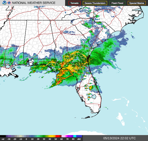
    Radar over Florida

    Straight from radar.weather.gov and regenerated by NOAA roughly every two minutes.

    NWS radar — the Southeast

    National Weather Service radar for the Southeast, covering North Carolina, South Carolina, Georgia, Florida and Alabama.

    Where precipitation is falling over Florida right now. The National Weather Service publishes these mosaics by region rather than by state, so the frame runs past the state line and neighbouring states are visible in it. Radar shows precipitation, not damage — a return over a county is not evidence that any particular building was hit.

    Radar imagery: the National Weather Service. Served directly from radar.weather.gov, a free US Government service, and regenerated by NOAA roughly every two minutes — your browser picks up new frames on its own. This site does not process, re-colour or re-time the imagery; it is the Weather Service’s own mosaic, unmodified. weather.gov

    This radar is informational and is not a safety resource. During an active weather event, the authority is weather.gov and your local emergency management agency. Follow them, not this page.

    Smoke & fire lane

    Smoke & fire alerts in Florida

    The National Weather Service issues a separate family of alerts for fire weather, dense smoke, air quality, blowing dust and volcanic ashfall. This lane reports that family for Florida, kept apart from the storm alerts above because the two answer different questions.

    Wildfire smoke is what drives smoke-damage losses, and it reaches a building through the same vents that keep an attic dry — which is why it belongs on a roofing page at all. Alerts describing particulate already in the air are listed ahead of fire-weather forecasts; that ordering is this lane’s own and is not a Weather Service ranking.

    0 active smoke or fire alerts · read from the National Weather Service at Oct 10, 7:02 AM EDT · refreshed every 10 minutes

    No active smoke or fire alerts

    The National Weather Service has no active fire weather, dense smoke, air quality, blowing dust or volcanic ashfall alerts covering Florida as of this refresh.

    An empty list here is the ordinary reading, not a fault and not a gap in the data. Most of the country carries nothing in this family on most days, and this lane fills itself the moment the Weather Service issues something.

    The 12 alert types this lane reports

    Every one is a National Weather Service product and is listed under the name the Weather Service gives it. Grouping them into families is ours; the names are not.

    Fire weather
    Fire WarningExtreme Fire DangerRed Flag WarningFire Weather Watch
    Dense smoke
    Dense Smoke Advisory
    Air quality
    Air Quality Alert
    Blowing dust
    Blowing Dust WarningDust Storm WarningBlowing Dust AdvisoryDust Advisory
    Volcanic ashfall
    Ashfall WarningAshfall Advisory

    The Weather Service defines each of these products and this site does not attempt to. What any one of them means, and the criteria an office issues it under, are at weather.gov.

    This lane is informational and is not a safety resource. It reports which National Weather Service smoke and fire alerts are active and where, on a ten-minute refresh cycle, so it can lag the Weather Service.

    During an active weather event, the authority is weather.gov and your local emergency management agency. Follow them, not this page.

    Smoke exposure and air quality are health matters, and this page does not address them. It does not tell you whether it is safe to be outdoors or to work, what an air quality index number means for you or for anyone in your household, or what respiratory protection to use. Those questions belong with a clinician and with the agency that issued the alert. The federal air-quality authority is airnow.gov.

    What smoke does to a roof assembly

    An active alert is a record of conditions, not a finding about any building. These are the standing references on the building-assembly side of a smoke or fire loss.

    Severe weather season in Florida

    Peak season

    June–November (Atlantic hurricane season); thunderstorms daily in summer

    Florida has the most frequent thunderstorm activity in the country during summer, and the sea-breeze storms that produce it run nearly every afternoon rather than as discrete events. Layered on top is the Atlantic hurricane season, which NOAA dates June 1 to November 30 and which peaks from mid-August into October. The combination that matters for roofing is duration plus wind-driven rain: a tropical system works the same seam for hours, where an afternoon storm works it for minutes.

    Seasons describe a pattern, not a schedule. The National Weather Service issues these products year-round, and the live list above is the only authority on what is actually running in Florida right now.

    What NOAA has recorded in Florida

    The archived record, not the live feed. Severe weather logged by the National Centers for Environmental Information over the covered years, split into the events NOAA keys to a county and the events it keys to a forecast zone.

    Between 2016 and 2026, NOAA recorded 6,192 county-level severe-weather events across Florida: 4,705 thunderstorm wind events, 919 hail reports and 568 tornadoes. Of the 919 hail reports carrying a measured size, 669 were 1.00 in across or larger.

    A further 1,037 events over the same period were recorded against National Weather Service forecast zones rather than counties — 767 tropical storm events, 122 hurricanes, 60 strong wind events, 39 high wind events and 24 winter storms. A forecast zone is not a county: it can span several or subdivide one, so these are reported here at state level and appear in no county total on this site.

    County-keyed events

    6,192

    2016–2026

    Zone-keyed events

    1,037

    statewide, not county-attributable

    Hail 1.00 in or larger

    669

    of 919 sized hail reports

    Tornadoes

    568

    in the county record

    Counties with the heaviest record

    Ranked by the number of county-keyed events NOAA recorded, 2016–2026. 67 of Florida’s counties carry a record in this dataset.

    • Leon County438largest hail 2.00 in (Baseball) · peak gust 73 kt (about 84 mph)
    • Duval County342largest hail 2.75 in (Softball+) · peak gust 66 kt (about 76 mph)
    • Jackson County255largest hail 1.75 in (Golf Ball) · peak gust 65 kt (about 75 mph)
    • Bay County209largest hail 2.00 in (Baseball) · peak gust 71 kt (about 82 mph)
    • Wakulla County209largest hail 1.00 in (Quarter - Half Dollar) · peak gust 75 kt (about 86 mph)
    • Walton County208largest hail 1.25 in (Quarter - Half Dollar) · peak gust 92 kt (about 106 mph)
    • Brevard County184largest hail 2.00 in (Baseball) · peak gust 71 kt (about 82 mph)
    • St. Johns County177largest hail 3.00 in (Softball+) · peak gust 56 kt (about 64 mph)

    Preliminary — not yet in the permanent archive

    396 further preliminary storm reports have been filed against Florida counties since June 1, 2026. They are counted separately from every archived figure above and are not added to any of them.

    Preliminary reports covering 2026-05-31 onward come from National Weather Service storm reports filed as events occur. They have not yet been through the quality-control review that produces the permanent archive, and individual reports may later be revised, combined or withdrawn.

    County figures and state figures. County figures count events NOAA recorded against a county (hail, thunderstorm wind and tornadoes). High wind, winter storms, ice storms, blizzards, heavy snow, hurricanes and tropical storms are recorded against National Weather Service forecast zones rather than counties, so they are reported at state level instead. Counts reflect events that were observed and reported.

    Source. Archived figures come from the NOAA National Centers for Environmental Information Storm Events Database, covering 2016 through May 31, 2026. Reports after that date come from NOAA Storm Prediction Center preliminary storm reports. Both are US Government works in the public domain. This is a record of past weather; the live alert list at the top of this page is the only authority on what is running in Florida now.

    What these storms do to a roof

    The damage mechanisms that matter in Florida, in the order they generate work here.

    Hail

    Hail damages an asphalt shingle in two ways at once. The impact knocks granules off the surface, and it can bruise or fracture the asphalt mat underneath without breaking the surface open. Granules are what shield the asphalt from ultraviolet light, so a roof that has lost them ages faster from that point on. A fractured mat is the reason hail damage is often described as latent: the roof may not leak the week of the storm, and the failure shows up later. On metal panels and metal accessories, hail leaves dents, which raises the separate question of whether the damage is cosmetic or has actually compromised the panel or its coating.

    Straight-line wind

    Wind damage on a shingle roof usually starts as a broken seal rather than a missing shingle. Uplift pressure is highest at the edges — rakes, eaves, ridges and hips — and along any line where the roof plane changes, so that is where tabs lift and the factory sealant strip lets go first. Once the seal is broken, a shingle that still looks fine from the ground is no longer bonded to the course below it and every later wind event works on the same spot. Wind also drives debris, and impact damage from a branch or from another roof’s material is a separate mechanism from uplift.

    Tropical systems

    A tropical system combines two things an ordinary thunderstorm does not: wind that lasts for hours instead of minutes, and rain driven sideways into every seam at the same time. The duration matters because uplift is cumulative — a seal that survives one gust may not survive the same gust repeated for six hours. Wind-driven rain also finds its way through vents, ridge products, flashings and wall-to-roof transitions that shed ordinary vertical rain without difficulty. Inland states see the same mechanism at reduced strength when a system tracks in from the coast.

    Why the storm date matters

    Property insurance works from a date of loss — a specific storm on a specific day over a specific area, not a general observation that a roof looks worn. That is why the county list and the effective and expiry times on each alert above are the useful part of this page: they are the National Weather Service’s own record that a given event covered a given county at a given time.

    It also matters because hail damage is frequently latent. A fractured shingle mat can take a long time to become a leak, so the gap between the storm and the discovery can be considerable — and by then, establishing which storm did it is a records question rather than an observation. An alert naming a county is not evidence that any particular building was damaged; it is evidence of what the weather was doing over that county, which is where an assessment starts rather than where it ends.

    Next steps in Florida

    Source: the National Weather Service. Every alert on this page comes from the NWS public alerts feed at api.weather.gov, a free US Government service, and is reproduced as the issuing office wrote it. The office that issued each alert is named on the alert itself.

    This site does not edit, summarise or re-grade Weather Service text. Alerts are filtered into two separate lists — the event types that affect roofs, and the smoke, fire and airborne-particulate family — and each list is sorted. Nothing else is changed, and no alert is moved between the two lists to suit a heading.

    weather.gov